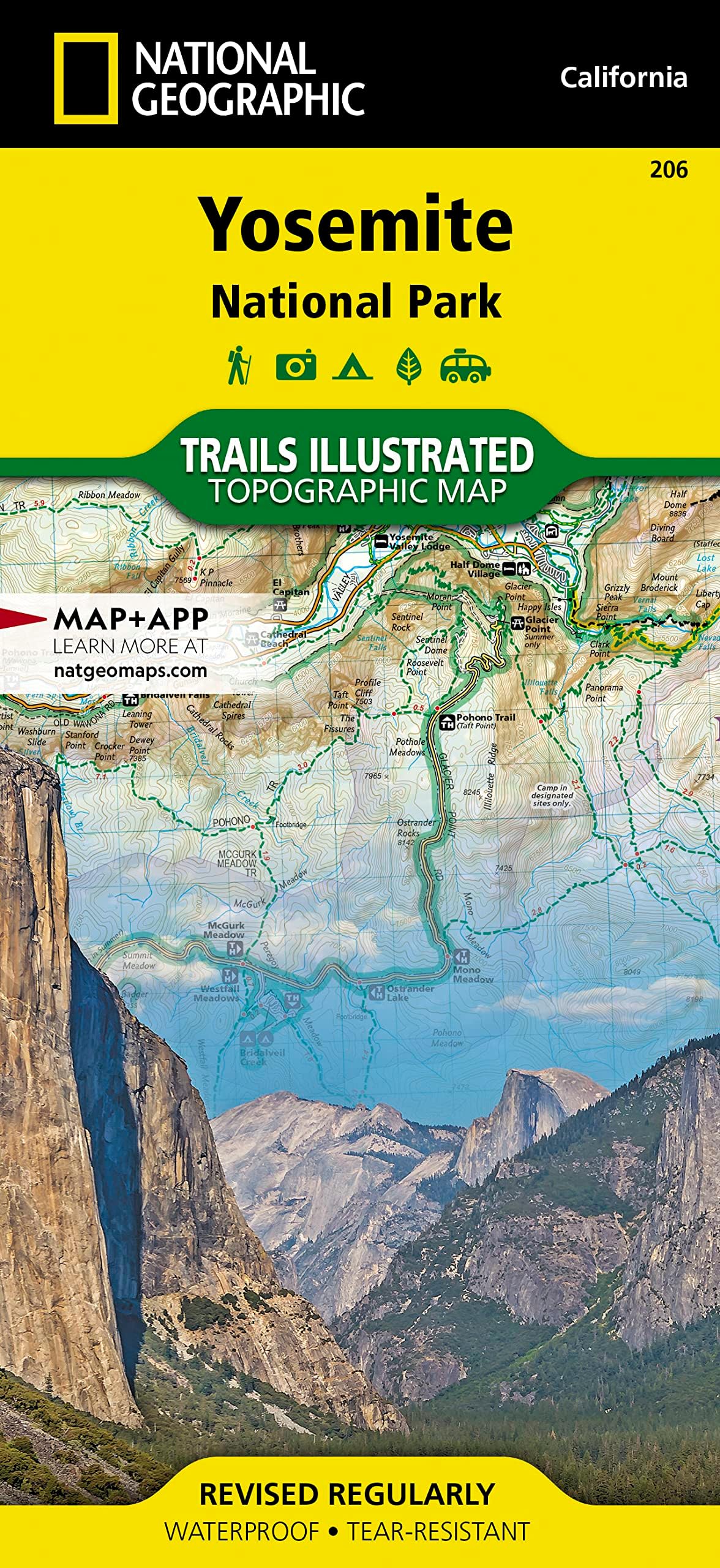
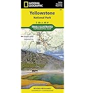
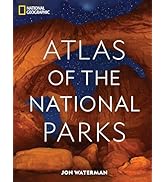
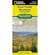
Yosemite National Park Map (National Geographic Trails Illustrated Map, 206)
Product ID: 1696303
Buy anything from 5,000+ international stores. One checkout price. No surprise fees. Join 2M+ shoppers on Desertcart.
Desertcart purchases this item on your behalf and handles shipping, customs, and support to Vietnam.
• Waterproof • Tear-Resistant • Topographic Map Explore the majesty of Yosemite National Park with National Geographic's Trails Illustrated map. Loaded with helpful information on camping, hiking, lodging, transportation, regulations, and safety, this map is an invaluable tool for casual park visitors and avid adventurers alike. Expertly researched and created in partnership with local land management agencies, the map features key areas of interest including Stanislaus National Forest, Emigrant Wilderness, Carson Iceberg Wilderness, Toiyabe National Forest, Hoover Wilderness, Inyo National Forest, Yosemite Wilderness, Sierra National Forest, and Ansel Adams Wilderness. Detail of the popular Tuolumne Meadows and Yosemite Valley are provided in inset maps. With almost 800 miles of mapped trails, the Yosemite National Park map can guide you off the beaten path and back again. The clearly marked trails include mileages between intersections. The map base includes contour lines and elevations for summits, passes and major lakes. Some of the many recreation features include: campgrounds, trailheads, tram tours, ski areas, river access, scenic overlooks, scenic byways, and interpretive trails. Every Trails Illustrated map is printed on "Backcountry Tough" waterproof, tear-resistant paper. A full UTM grid is printed on the map to aid with GPS navigation. Other features found on this map include: Ansel Adams Wilderness, Bridalveil Fall, Cathedral Range, El Capitan, Emigrant Wilderness, Excelsior Mountain, Hoover Wilderness, Illilouette Falls, Inyo National Forest, Lake Eleanor, Lower Yosemite Fall, Matterhorn Peak, Mount Dana, Mount Lyell, Mount Ritter, Nevada Fall, Ribbon Fall, Ritter Range, Sierra National Forest, Silver Strand Falls, Stanislaus National Forest, Tioga Pass, Toiyabe National Forest, Upper Yosemite Falls, Vernal Fall, Yosemite National Park, Yosemite Valley. Map Scale = 1:80,000 & 1:40,000 Sheet Size = 37.75" x 25.5" Folded Size = 4.25" x 9.25" Review: Easy to Read with Sufficient Details - I'm a long time Scouter and like having maps in addition to my trail apps. This is a durable map that greatly supplemented my digital navigation. Review: Helpful map, especially for such a massive park like Yosemite! - Now this is a must have. The park is just massive! Absolutely have to have the map, I haven’t visited the park yet, so I cannot really comment on accuracy and helpfulness, but with all the trails out there, especially the wilderness ones, I don’t see how anyone would make it without GPS and a plan B for when GPS doesn’t work. They will probably need to update the map once construction on some of the trails are complete, I know the trams are finally gone so we can go back to a natural trail setting with much more peace and quite, that’s the way it has to be to make sure we keep it the way we found it! Support your national parks! They are the best!


| Best Sellers Rank | #19,571 in Books ( See Top 100 in Books ) #3 in Yosemite California Travel Books #19 in Pacific West United States Travel Books #30 in Hiking & Camping Excursion Guides (Books) |
| Customer Reviews | 4.7 out of 5 stars 519 Reviews |
N**)
Easy to Read with Sufficient Details
I'm a long time Scouter and like having maps in addition to my trail apps. This is a durable map that greatly supplemented my digital navigation.
F**R
Helpful map, especially for such a massive park like Yosemite!
Now this is a must have. The park is just massive! Absolutely have to have the map, I haven’t visited the park yet, so I cannot really comment on accuracy and helpfulness, but with all the trails out there, especially the wilderness ones, I don’t see how anyone would make it without GPS and a plan B for when GPS doesn’t work. They will probably need to update the map once construction on some of the trails are complete, I know the trams are finally gone so we can go back to a natural trail setting with much more peace and quite, that’s the way it has to be to make sure we keep it the way we found it! Support your national parks! They are the best!
M**E
Great map, super resistant
Waterproof + containing a lot of details. Perfect to plan the trip and while hiking.
G**H
good overview map, fine for hiking, but not my favorite
This map weighs 3.2 ounces and covers all of Yosemite National Park. Its scale is 1:80,000, or 1 inch = 1.26 miles. I own several topographic trail maps of Yosemite, and this one is the most beautiful. Trail distances are marked. I will probably never hike with this map, because my Tom Harrison maps are smaller (thus lighter) and more zoomed in. The Tom Harrison Yosemite High Country trail map covers most of the places I keep going back to, and weighs half as much as this map. However, for a trip that includes visits to locations all over the park (e.g. if you're driving and want to do day hikes at Hetch Hetchy and Yosemite Valley and Tuolumne Meadows) the National Geographic map might make a lot of sense. I do like this map for brainstorming my next hike at home -- you can see a lot of park at once, though the area north of Hetch Hetchy is on the back of the map. It's also nice that it includes some of the wilderness and national forest areas adjacent to Yosemite. Planning a trip along the border between Tom Harrison's Yosemite and Mammoth High Country maps was a nuisance I could have avoided if I'd had this map at the time. I'm glad I have this map, though it's not the first Yosemite map I'd recommend for hiking, especially if you're going to be staying in a single area.
J**R
Great map
We used this map for a backpacking trip in Yosemite this summer. We were also pleased to see that this was one of the maps they were selling in the ranger station. We used this map for planning our trip and brought it as reference throughout. The map is a little big, but that’s fine. We appreciated the insets for specific locations.
A**R
it is good enough
maybe i am weird but i like to have a topo map when i hike far enough off the the tourist routes (e.g. 20 miles round trip). As the park ranger said, this was her trusty topo map. A finer resolution map would have been appreciated on specific trails, but this is a good over view map for most trips to the park for your initial visits. And if you get as far away from civilization as i do, an "old school" backup to whatever your favorite electronic navigation app is worth the weight and space.
N**H
Spit on
These maps are spot on. When your on the mountain, service can be spotty or even none. This map guided us 65 miles across Yosemite in 11 days backpack camping. Held up to water, held up to being opened and folded probably 100 times. Elevation was correct, mileage. Everything. I framed it with a bunch of pictures we took and drew out the route we did.
K**R
have lots of great information. They are waterproof and extremely durable
Anytime I go to a National Park, I always get at Nat Geo map. First of all, do not back country hike without a topographical map. My wife and I hiked the Grand Canyon without one, and we nearly missed our first water stop because we couldn't figure out where on our internet printed map we were. Lucky for us, when we did find our water stop there was a guy who lent us his Nat Geo map for the rest of our hike. These maps are detailed, have lots of great information. They are waterproof and extremely durable.
C**N
eccellente qualità, ottima grafica
Ottima, al tatto sembra carta ma in realtà è di plastica, non si strappa e non di bagna. Solo un po' troppo grande, per comprendere tutto il parco le parti più frequentate sono veramente una piccola porzione della mappa.
N**N
voyage
même commentaire que pour les cartes précédentes notre voyage est super bien préparé grâce a ces cartes nous nous sommes rendu compte que notre première intention 2 nuits une journée nous auraient vraiment frustrés a nous la découverte !et le plaisir
D**S
Good
Enough detail to hike the trails, good quality.
R**S
Very good
very good for all hikers
P**5
Useful for long hikes
Very detailed map which is very helpful if you want to to a long hike in Yosemite (one full day or more, for example John Muir Trail). However you can find all the information on site if you only do short day hikes.
Trustpilot
2 weeks ago
2 weeks ago